
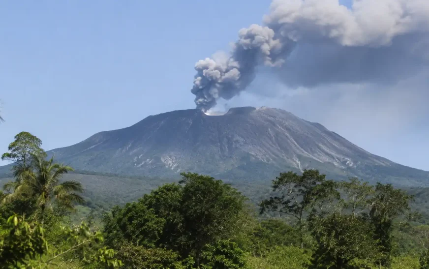
Mount Dukono is one of Indonesia’s most active volcanoes, located on Halmahera Island in North Maluku. It is famous for its frequent eruptions, powerful explosions, and large clouds of volcanic ash. Unlike many volcanoes that remain quiet for years, Mount Dukono has experienced almost continuous volcanic activity since 1933. Its dramatic landscape attracts scientists and volcanic researchers from around the world. However, the volcano also creates serious risks for nearby communities and visitors. Understanding its location, geological history, eruption patterns, and safety challenges helps explain why this natural landmark deserves attention.
Where Is Mount Dukono Located?
Mount Dukono is situated on Halmahera Island in North Maluku, Indonesia. Halmahera belongs to the Maluku Islands, an eastern Indonesian island group. The volcano stands in the northern part of the island, near the Galela region. Its remote location makes access more difficult than visiting popular Indonesian volcanoes. The surrounding landscape includes tropical forests, small settlements, and rugged volcanic terrain. The nearby communities experience the effects of volcanic activity, especially falling ash. Mount Dukono is also part of Indonesia’s wider volcanic belt, where several active volcanoes shape the islands.
The volcano’s geographical position is closely connected to Indonesia’s complex geology. The country lies along the Pacific Ring of Fire, where tectonic plates interact beneath the Earth’s surface. These movements create conditions that allow magma to rise and produce volcanic eruptions. Halmahera is surrounded by active geological zones, making it an important region for volcanic research. Mount Dukono is particularly interesting because its activity continues over long periods. Researchers study its eruptions to understand volcanic processes, ash movement, and possible dangers. Its location also helps explain why monitoring remains important.
Mount Dukono Height and Geological Features
Mount Dukono has a complex volcanic structure with several peaks and overlapping craters. Its height is reported differently by various geological sources. Indonesian authorities commonly list its elevation at approximately 1,087 metres above sea level. The Smithsonian Global Volcanism Program records a higher figure of 1,273 metres. These differences can reflect different mapping methods and reference measurements. The mountain’s broad shape makes it different from a simple, sharply pointed volcanic cone. Its landscape contains old volcanic deposits, rough slopes, and active crater areas that continue changing through eruptions.
The volcano’s geological structure includes the active Malupang Warirang crater area. Another important feature is Malupang Wariang, a large crater near the main summit complex. These volcanic openings have played important roles in the mountain’s eruption history. The surrounding ground contains ash, hardened lava, and other materials produced by earlier activity. Over time, repeated eruptions have changed the shape of the landscape. Scientists examine these features to understand how magma moves beneath the surface. Such observations also help identify areas that may face greater risks during future volcanic activity.
Mount Dukono Eruption History
Mount Dukono has a long record of volcanic activity, including several important historical eruptions. One major event occurred in 1550, when a powerful eruption produced lava flows. The lava filled a narrow sea passage between Halmahera and the nearby Gunung Mamuya volcanic cone. Historical records also mention smaller eruptions during 1719, 1868, and 1901. These events show that the volcano was active long before modern monitoring systems existed. However, scientists have limited information about some older eruptions. Historical reports and geological evidence help researchers reconstruct its volcanic behaviour.
A particularly important period began in August 1933, when Mount Dukono entered an almost continuous eruptive phase. Activity has included explosions, ash emissions, volcanic gases, and occasional lava flows. The Smithsonian Global Volcanism Program records this eruptive period as continuing through 2026. Its frequent explosions make the mountain one of Indonesia’s consistently active volcanoes. Some eruptions produce relatively small ash clouds, while others become more powerful. This changing behaviour makes regular observation essential. Scientists use ground instruments and satellite images to understand its activity and identify possible changes in eruption strength.
Why Is Mount Dukono So Active?
Mount Dukono’s activity is connected to the movement of tectonic plates beneath Indonesia. The region belongs to a complex volcanic zone where oceanic crust moves beneath other sections of the Earth’s surface. This process is known as subduction. As the descending plate moves deeper, conditions allow magma to form and rise toward the surface. When pressure builds inside a volcano, gases and molten rock can escape through openings. These processes help explain why Mount Dukono experiences repeated eruptions. Its geological setting provides a natural environment for ongoing volcanic activity.
Another important factor is the movement of volcanic gases and magma through underground pathways. Pressure changes can produce explosions that send ash and rock fragments into the atmosphere. Sometimes, volcanic material escapes without creating a particularly large explosion. However, even smaller eruptions can become dangerous when people are close to the crater. Mount Dukono regularly releases ash and sulfur dioxide, making its surroundings difficult during active periods. Scientists study these emissions because they provide useful information about underground conditions. Monitoring changes helps authorities understand potential hazards and communicate safety warnings to nearby communities.
Mount Dukono Eruption 2026: What Happened?
Mount Dukono experienced a particularly serious eruption on May 8, 2026. The eruption produced a large ash column that reportedly reached approximately 10 kilometres into the atmosphere. Several hikers were caught in the dangerous volcanic activity near the mountain. Three people died, and others were injured during the incident. The tragedy attracted international attention because visitors had entered an extremely dangerous volcanic area. Emergency teams faced difficult conditions while conducting rescue and recovery operations. The event demonstrated how quickly volcanic activity can threaten people exploring active mountain environments.
The eruption also attracted attention from scientists monitoring volcanic activity through satellites. Images captured from space showed a large ash cloud spreading away from the mountain. NASA reported additional volcanic activity, including frequent explosions during the days following the tragedy. Between May 9 and May 16, Indonesian monitoring records showed an average of 52 eruptive events daily. Ash columns varied considerably in height during this period. These observations demonstrated that the volcano remained highly active after the deadly event. The tragedy also strengthened discussions about visitor safety and responsible volcanic tourism.
Hazards and Safety Risks Around Mount Dukono
Mount Dukono creates several hazards because its eruptions can happen frequently and sometimes without much warning. Volcanic ash is one of the most common dangers. Fine ash particles can irritate the eyes, damage breathing systems, and reduce visibility. Larger explosions may also throw hot rocks and volcanic bombs around the crater. These materials can cause serious injuries or death to anyone standing nearby. Volcanic gases create another concern because some emissions can be harmful when inhaled. These combined risks make approaching the active crater extremely dangerous, even during apparently quiet periods.
Another important danger is the movement of volcanic material down the mountain. Hot ash, gases, and rocks can travel quickly during certain explosive events. Heavy rainfall can also mix volcanic deposits with water, creating dangerous mudflows called lahars. Communities around Mount Dukono may experience falling ash depending on wind direction and eruption strength. Authorities therefore advise residents to keep protective masks available. Visitors should follow official warnings and avoid restricted areas. The recommended exclusion zone around Malupang Warirang crater is four kilometres. Staying outside this area is essential for reducing exposure to volcanic hazards.
Can Tourists Visit Mount Dukono?
Mount Dukono is known for its dramatic volcanic landscape, which can attract adventurous travellers and nature enthusiasts. Its remote location offers a different experience from Indonesia’s more popular tourist destinations. Visitors may find the surrounding forests, volcanic terrain, and distant views interesting. However, this is not an ordinary mountain destination. Its frequent eruptions create serious safety concerns for anyone planning an outdoor adventure. The mountain’s natural beauty should never distract visitors from its dangers. Understanding local conditions is essential before considering any travel around the Halmahera region.
Climbing an active volcano requires careful planning and reliable safety information. Mount Dukono is particularly challenging because explosions can occur while people are exploring nearby areas. Indonesian authorities recommend staying at least four kilometres away from the Malupang Warirang crater. Visitors should respect this restriction and avoid unofficial climbing routes. They should also check volcanic alerts before travelling through the surrounding region. Local authorities may introduce additional restrictions when activity increases. Anyone interested in volcano tourism should consider safer viewing locations instead of approaching active volcanic openings.
Mount Dukono Current Activity and Monitoring
Mount Dukono continues to receive attention from Indonesian volcanic monitoring authorities. Scientists observe its activity using seismic instruments, visual reports, and satellite technology. These systems help detect explosions, volcanic tremors, and changes in ash emissions. The information supports public safety decisions and helps authorities communicate important warnings. Because the volcano erupts frequently, monitoring is especially important for nearby communities. Researchers also examine changes in volcanic gases and ground temperatures. These observations provide useful clues about what may be happening beneath the mountain’s surface.
According to the Smithsonian Global Volcanism Program, Mount Dukono remained eruptive in November 2026. On November 3, monitoring reports recorded 12 explosions, with ash plumes reaching approximately 900 metres above the vent. The alert level remained at Level 2, known as Alert, on Indonesia’s four-level system. Authorities continued recommending a four-kilometre exclusion zone around the active crater. Volcanic activity can change quickly, so these details should not be treated as permanent. Residents and travellers should always follow the latest official safety instructions.
Frequently Asked Questions About Mount Dukono
1. Where is Mount Dukono located?
Mount Dukono is located on Halmahera Island in North Maluku, Indonesia.
2. Is Mount Dukono an active volcano?
Yes, it has experienced almost continuous volcanic activity since 1933.
3. How tall is Mount Dukono?
Its elevation is commonly reported as 1,087 metres, although some geological sources list 1,273 metres.
4. When did Mount Dukono last erupt?
It was still erupting on November 3, 2026, according to monitoring reports.
5. Is Mount Dukono safe for climbing?
No. Its frequent explosions and volcanic hazards make climbing extremely dangerous. Authorities recommend staying four kilometres away from its active crater.
Conclusion
Mount Dukono is one of Indonesia’s most fascinating and consistently active volcanoes. Located on Halmahera Island, it has experienced almost continuous eruptions since 1933. Its geological structure, frequent ash explosions, and historical eruptions make it important for scientific research. However, its activity also creates serious dangers for nearby communities and visitors. The deadly May 2026 eruption highlighted the importance of respecting volcanic safety restrictions. Although its natural landscape attracts attention, approaching the active crater is extremely risky. Readers interested in natural disasters can also explore our articles about volcanic eruptions, earthquakes, and Indonesia’s natural wonders.